
Site Development and Utilities in Santa Fe and Northern New Mexico
Before a building can be designed well, someone needs to know what is under the lot. In northern New Mexico, that question has several layers. There is soil and rock, which determines foundations and cost. There is water, in the form of arroyos, floodplains and the occasional hard summer storm. There is infrastructure, which may stop a long way from the property line. And there is history: the Galisteo Basin holds abandoned Tanoan villages, the Lamy Junction Community is an archaeological site of fourteen Coalition Era pueblos and other structures, and the Pueblo Alamo site lies near the junction of I-25 with US 285 in the Eldorado area.
Site development is the work that answers all of those questions in order, and does it before a foundation crew arrives. We take it slowly on purpose. A parcel that is cleared, graded, drained and served with utilities in a considered sequence will carry a building well, while one that is rushed tends to reveal its problems after the owner has stopped being able to fix them cheaply.
What we learn before we move any dirt
The first step is research. We review surveys, geotechnical reports, floodplain maps, utility records and prior permits, and then we walk the site. We look for drainage paths, rock outcrops, old foundations, trees and signs of previous disturbance. For parcels near known cultural resources, we ask whether survey or monitoring is required, and we put that question to the right agency early.
The second step is to decide what the site wants to be. A building oriented along the contour is cheaper than one fighting the slope, and a driveway that follows the natural grade avoids retaining walls. Owners in a design-conscious area tend to want this thinking done thoughtfully, with the least possible scarring of the land, and the board may expect the same. This overlaps with preconstruction estimating, where site costs are a major line.
The work itself, in sequence
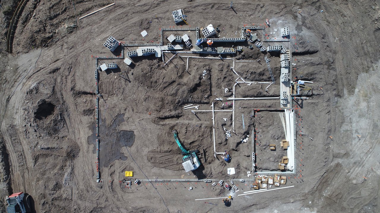
Site work usually proceeds in this order: erosion control and clearing, demolition of anything that must go, rough grading, utilities in trenches, subgrade preparation, drainage structures, retaining walls and finally paving and landscaping. Sequence matters. Utility trenches cut through finished pavement cost far more than trenches laid first, and a drainage structure built after the building often has to work around it.
Utilities include water, sewer or septic, electric, gas, communications and fire service. On rural parcels near Pojoaque, Eldorado or the Galisteo area, water and wastewater may be on-site systems, which have their own design, testing and approval needs. We coordinate with the utilities, the engineers and the regulators so that each connection is inspected before it is covered.
Reviews that attach to land
Santa Fe County's Sustainable Land Development Code incorporated the Community College District plan in 2016, and that plan covers about 17,000 acres south of the city. Rancho Viejo, planned as seven villages, reserves half the land for parks, open space and trails and 15 percent of homes as affordable housing. Parcels in such areas come with obligations that go beyond ordinary grading, and we read them closely.
Elsewhere, Agua Fria Village was designated a Traditional Historic Community by the Santa Fe Board of County Commissioners in 1995, and the historic districts in the city have their own review. The 2021 New Mexico Commercial Building Code governs structures, but grading, drainage and access are reviewed by city and county staff, and by state agencies when roads or waterways are involved. We prepare submissions carefully, because incomplete ones sit in a queue.
Equipment and trade partners on the ground
We schedule and supervise the work that defines the site: clearing, grading, trenching, backfill, base course and concrete flatwork. The operators we work with know how to work around buried utilities, how to compact fill in thin lifts and how to handle rock. We use survey control throughout, and we check grades before pavers or foundations arrive.
For specialized scopes such as large pipe installations, lift stations, retaining systems and asphalt paving, we manage subcontractors we know. Having our own supervision on the dirt gives us the ability to respond when the ground surprises us, as it sometimes does, and to adjust the plan with the owner and the engineer.
Where site budgets move
Rock, distance and water move site budgets more than anything else. Rock excavation costs much more than soil, and a geotechnical report with enough borings is cheap insurance. The distance from the property to utility connections determines the length of trenches. Water, from storms or high groundwater, can force detention ponds, larger pipes and erosion control that was not anticipated.
Elevation brings added costs: frost depth for utilities, snow removal planning and a shorter earthwork season. Dixon, for instance, sits on Embudo Creek, a tributary of the Rio Grande, and Espanola sits where the Rio Grande, Rio Chama and Rio Santa Cruz meet, and sites in such valleys must take floodplain into account. Owners planning an industrial project can compare site costs with warehouse construction or truck courts and dock aprons.
Trenches, traffic and tidy sites
Excavation is among the most hazardous work on a project. We shore or slope trenches to the required standard, locate buried utilities before digging, keep spoil piles back from edges and ensure that a competent person inspects trenches daily. Traffic control around access roads is planned in advance, particularly on roads like NM 502, where a safety corridor has existed for most of its length since November 2005.
We also keep the site clean. Mud on roads, dust in dry weather and runoff in storms bother neighbors and regulators alike. Silt fence, stabilized entrances, water trucks and sweeping are routine, and we maintain them without waiting for a complaint. For public and institutional owners, see how we serve government and public-sector clients.
Start with the land
Send us the parcel, the survey and any reports, and we will tell you what we see. A site visit, a conversation about review and a rough budget can come before design money is spent. For sites on the south side, our notes on Rancho Viejo show how planned communities shape the work.
Questions Owners Ask
How do I know whether a parcel has archaeological issues?
Start with a records check through the appropriate state and local offices, then ask a qualified archaeologist whether survey is warranted. Parcels near known sites such as those in the Galisteo Basin or around Lamy are likelier to need it. We raise the question before purchase when we can, and before grading always.
What is the best time of year for earthwork?
Late spring through early autumn is easiest, though summer storms can interrupt. Winter work is possible with frost protection, but frozen ground complicates compaction and concrete. We plan the sequence so that wet and frozen months are used for less sensitive tasks.
Who handles utility connections?
We coordinate them, but each utility controls its own connection process and schedule. We submit applications early, prepare trenches and conduits to their standards and arrange for inspection. In rural areas where on-site wells and septic systems are used, we also coordinate testing and approvals.
How do you control stormwater during construction?
With erosion and sediment controls that fit the site: silt fence, rock entrances, check dams, inlet protection and stabilized stockpiles. We inspect them after storms and repair them promptly. Permanent drainage, such as swales and detention basins, is built early so it can serve during construction.